Unmanned aerial vehicles (UAVs), or drones, have dramatically transformed the landscape of environmental monitoring and mapping. These sophisticated machines are much more than mere toys; they represent a convergence of cutting-edge technology capable of autonomously surveying landscapes, creating detailed maps, and even producing immersive 3D visualizations of real-world settings. A recent innovation developed by researchers from Sun Yat-Sen University and Hong Kong University of Science and Technology, called SOAR, exemplifies the potential of UAVs to revolutionize the fields of urban planning, cultural heritage conservation, and video game design.
SOAR is a pioneering multi-UAV system designed for rapid autonomous environment reconstruction. This system marks a significant advancement in the way UAVs operate by enabling them to swiftly explore and photograph spaces simultaneously. The researchers behind SOAR aim to address a critical gap identified in existing UAV methodologies: the dual tendency of relying either on time-consuming model-based approaches or less efficient model-free tactics. According to Mingjie Zhang, a co-author of the study: “The need for efficient and high-quality 3D reconstruction using UAVs motivated our research. We sought to merge the best aspects of both methodologies into a cohesive system.”
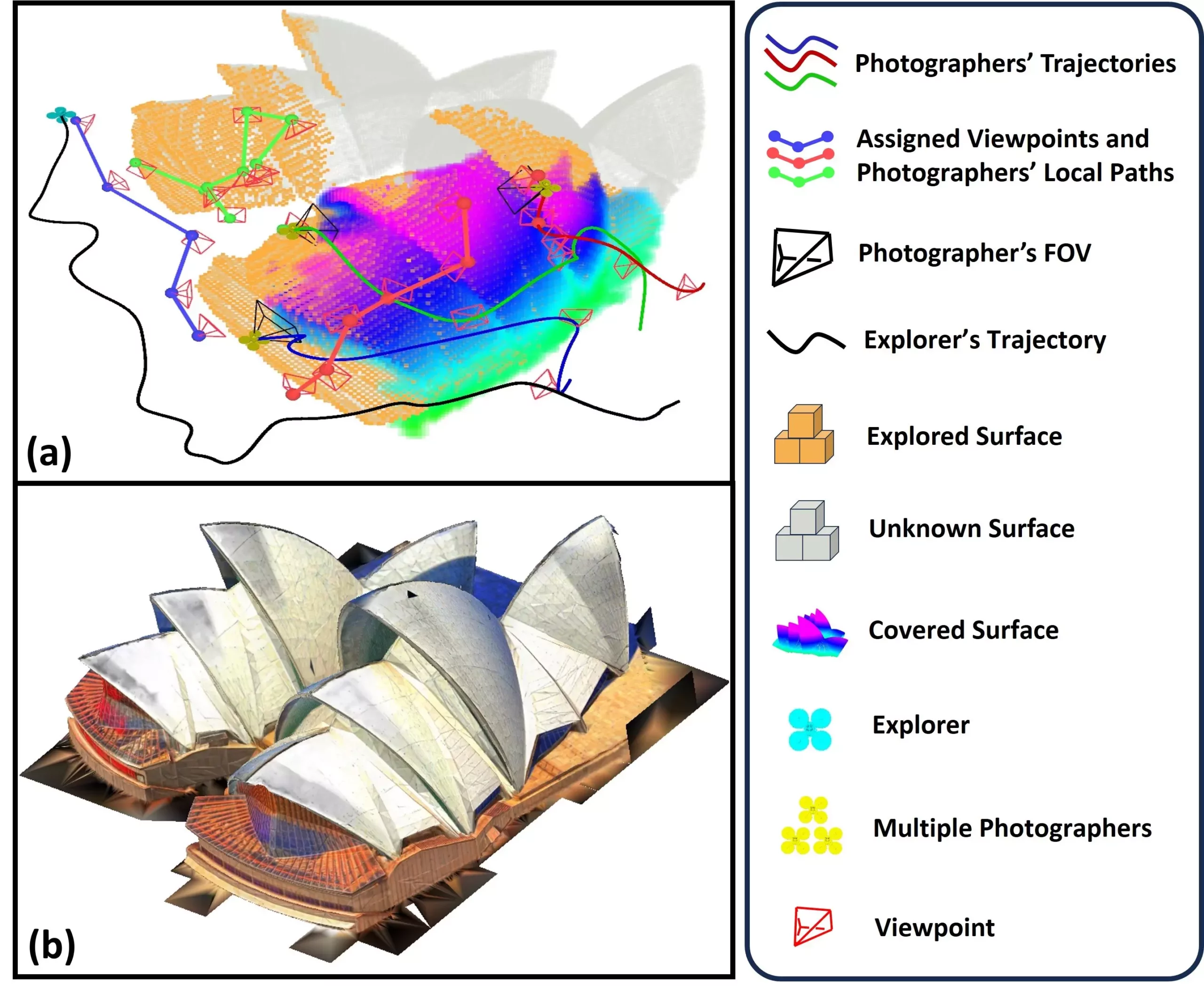
The approach involves a heterogeneous UAV fleet characterized by a primary “explorer” UAV equipped with LiDAR technology and a group of secondary UAVs tasked with capturing high-resolution images. This strategic division of functions allows for faster data accumulation and more detailed reconstructions. As the explorer maps out the surroundings, the secondary UAVs collect photographic data necessary for creating textured, layered 3D models.
One of the standout features of the SOAR system is its innovative incremental viewpoint generation technique. As the explorer UAV captures data about the environment, it dynamically adjusts and optimizes the viewpoints of the subsequent photographers. This efficient task assignment strategy ensures that the UAV team operates cohesively, maximizing data collection while minimizing unnecessary repetitions.
The core mechanism involves clustering viewpoints and utilizing a novel method known as “Consistent-MDMTSP,” which ensures that each UAV has a well-defined and efficient path for capturing images. Such a structured approach is pivotal in maintaining systematic task execution and capturing necessary visual data without hindrance.
The implications of SOAR extend across various fields, showcasing its remarkable versatility. For instance, in urban environments, the capability of creating detailed 3D models can revolutionize city planning and management. Furthermore, in cultural heritage preservation, SOAR could aid in reconstructing historic sites, allowing historians to digitally document artifacts and environments that might be at risk.
In the event of natural disasters, this system could play a crucial role in damage assessment and emergency response strategies. First responders could deploy SOAR to identify affected areas quickly, enabling them to allocate resources efficiently. Moreover, the construction and infrastructure inspection domains could greatly benefit from SOAR’s capabilities, facilitating clearer maps and understanding of sites undergoing development.
Looking ahead, the team is enthusiastic about addressing challenges that accompany real-world deployments, such as potential localization errors and communication disruptions that may arise in varied environments. Zhang highlights the importance of bridging what is known as the “Sim-to-Real Gap.” The objective is to create task allocation strategies that will further improve teamwork among UAVs and allow for more timely and effective mapping processes.
Moreover, enhancements such as scene prediction and informative processing modules could facilitate the system’s capacity to anticipate environmental structures, thereby improving efficiency. Adding active reconstruction techniques could enable real-time adjustments based on immediate feedback, allowing SOAR to refine its operational processes mid-flight. Incorporating factors such as camera angle and image quality into its planning would undoubtedly elevate the system’s ability to generate high-fidelity 3D reconstructions.
The SOAR system represents a forward leap in UAV technology, with immense potential to redefine how we understand and map our environments. By merging various methodologies into a powerful, integrated approach, the researchers have laid the groundwork for future innovations that could transform numerous industries. As exploration progresses, SOAR’s ability to adapt and improve will be the key to unlocking its full potential, demonstrating that the future of 3D reconstruction is not just promising—it’s already taking flight.


Leave a Reply