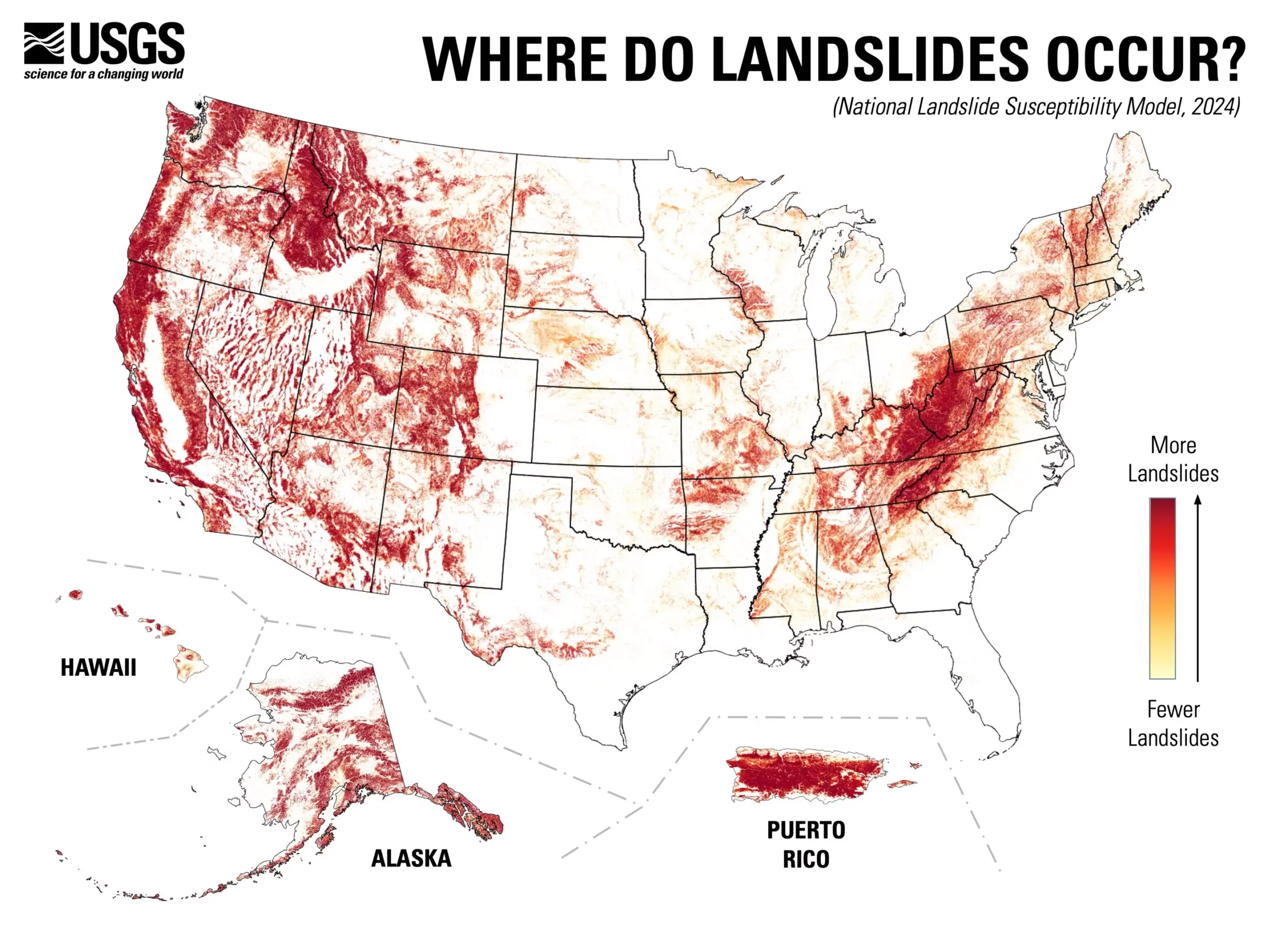
In an important development for environmental safety and urban planning, the U.S. Geological Survey (USGS) has unveiled a nationwide landslide susceptibility map that reveals a startling statistic: nearly 44% of the entire United States is at risk for potential landslides. This innovative assessment provides an intricate overview of landslide risks on a county-by-county basis, showcasing areas where geology may lead to damaging, disruptive, or lethal landslide events, as well as regions that pose little to no risk. With such comprehensive data now at hand, local authorities, planners, and engineers are better equipped to take proactive measures in risk-reduction and effective land-use planning.
The ramifications of such a detailed map are vast. As noted by USGS research geologist Ben Mirus, the availability of this national landslide susceptibility tool is a significant stride towards creating a more hazard-ready populace. In previous years, detailed mappings were limited to regions recognized as having high landslide risks, leaving many areas under-monitored. By expanding the assessment to include a plethora of previously underrepresented landscapes, the USGS paints a clearer picture of where landslide hazards might occur across the nation. This improvement in data accessibility is crucial for informing communities about potential hazards that could strike with little warning.
One of the standout features of the new landslide susceptibility map is the advanced methodologies used to create it. The USGS team synthesized an impressive inventory of nearly one million previous landslide incidents alongside high-resolution elevation data derived from the USGS 3D Elevation Program. By applying state-of-the-art computational techniques to these datasets, researchers developed a more nuanced, high-accuracy model for landslide susceptibility.
This approach marks a departure from traditional methodologies that relied on less precise continental and global maps. The higher resolution data ultimately yields a more reliable tool for stakeholders in identifying both vulnerable and safe areas regarding landslide threats.
The implications of this new map extend beyond mere identification of hazards. Urban planners and risk management professionals can leverage this information for strategic decision-making around new development projects. By pinpointing unstable areas, planning departments can prioritize safety measures and mitigation strategies, ensuring that structures are built to withstand potential geohazards.
Moreover, this tool can serve as a foundational element for future research into landslide occurrences. Areas identified as having heightened risk may warrant further investigation, enabling researchers to refine their understanding of local geological conditions and develop targeted risk interventions.
The release of the USGS landslide susceptibility map is a pivotal moment in enhancing national awareness and preparedness regarding these natural disasters. With nearly half of the nation now identified as susceptible to landslide activity, it is crucial for individuals, communities, and urban planners to utilize this information effectively. By fully integrating these insights into planning and development, the U.S. can foster resilience in the face of geological hazards while promoting the safety and well-being of its residents.


Leave a Reply