Air quality remains a critical concern in today’s rapidly industrializing world, with pollutants like nitrogen dioxide (NO2) standing at the forefront of this environmental dilemma. The recent leap in satellite technology has unlocked unprecedented opportunities for measuring air pollution, providing novel insights into the sources and effects of nitrogen dioxide emissions. The change is not just incremental; it significantly enhances our capabilities to track down emissions with pinpoint accuracy, paving the way for improved environmental strategies.
Nitrogen dioxide is an atmospheric nemesis—a pollutant that emerges chiefly from human activities such as combustion from vehicles, industrial processes, and power generation. Its prevalence has been tied to detrimental health outcomes, including respiratory problems, asthma, and other chronic lung diseases. Moreover, NO2 plays a critical role in the formation of smog, contributing to the yellow-brown haze that blankets many urban centers. It is essential not only to detect NO2 in the air but also to quantify its emissions to understand its impact on air quality and public health.
Historically, measuring NO2 concentrations through satellite imagery has faced its share of limitations. Legacy satellite technology, while instrumental, often lacked the finer spatial resolution required to identify specific emission sources. This inadequacy has stymied efforts to formulate targeted interventions against pollution hotspots.
Breakthroughs in Satellite Technology
A transformative study, recently published in the *Proceedings of the National Academy of Sciences*, showcases a new approach that utilizes imagery from the Copernicus Sentinel-2 satellite to identify NO2 plumes originating from power plants. This advancement represents a pivotal shift in air pollution monitoring and understanding, shifting the focus from broad assessments to detailed investigations of individual emission sources. It’s evident that leveraging high-resolution satellite technology can enhance our insight into NO2 emissions more effectively than traditional methods.
The Copernicus Sentinel-2 satellites were designed primarily for land and resource monitoring, but recent findings reveal their potential for air quality assessments. Equipped with advanced imaging capabilities, these satellites can capture detailed, high-resolution images that expose nitrogen dioxide emissions with remarkable accuracy. This is a game-changer for regions characterized by multiple pollution sources in close proximity, where discriminating between different emission points has been incredibly challenging.
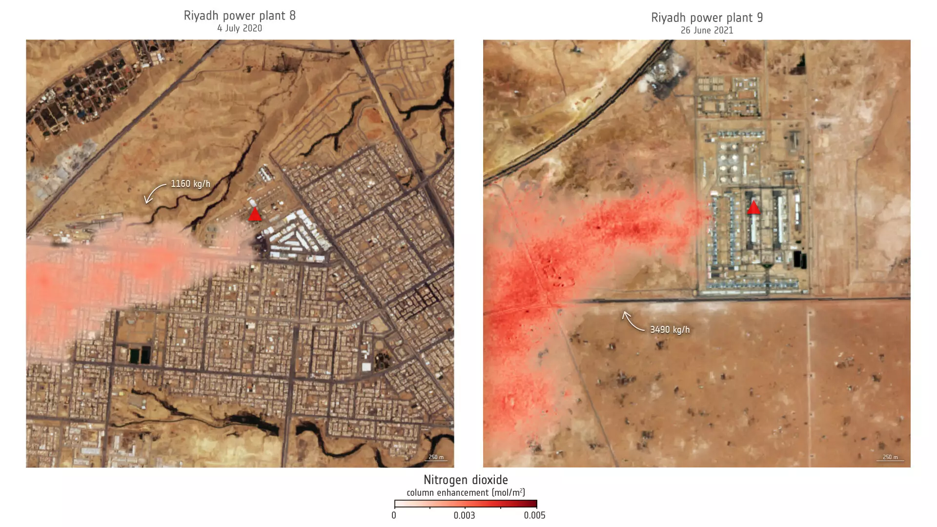
The study primarily focused on power plants in Saudi Arabia and the United States, employing images from the blue and ultrablue bands of the satellites. The capacity to differentiate emissions from individual power plants allows for a granular understanding of when and where pollution spikes occur. For instance, observations from a power plant in Riyadh highlight significant seasonal variations, with peak emissions correlated to the increased usage of air conditioning during the summer months. This kind of temporal data is invaluable and enables regulators and environmentalists to anticipate pollution trends based on energy consumption patterns.
Daniel Varon, the lead researcher, remarks on the transformative capacity of combining the data from Sentinel-2 with long-term records from Landsat satellites, profoundly enhancing our ability to track emission trends over time. This fusion of data sources not only broadens our understanding of NO2 emissions but also enriches our toolkit for addressing air quality issues comprehensively.
Challenges and Limitations Ahead
However, it is important to recognize that using advanced satellite technology comes with its own set of challenges. High-resolution satellite imagery is often most effective over bright, uniform surfaces while struggling in areas characterized by complex geographical features or darker surfaces. Despite these limitations, the ability to identify and monitor pollution sources remains a powerful leap forward.
The information gleaned from satellites like Sentinel-2 and Landsat could be crucial in regions lacking traditional air quality monitoring infrastructure. Policymakers and environmental agencies can utilize this data to craft effective strategies aimed at decreasing NO2 emissions and improving public health outcomes.
The Future of Pollution Monitoring
The ongoing advancements in satellite technology signify a bright future for environmental monitoring. With the planned launch of Sentinel-2C in September 2024, we can expect to see enhanced capabilities for tracking land use and air quality even further. This mission will continue to generate critical data by providing high-resolution images across various spectral bands.
As we stand on the cusp of this new era in air quality monitoring powered by satellite technology, the potential for positive change is immense. Understanding the granular dynamics of nitrogen dioxide emissions and their sources can supercharge environmental policies and systems, ultimately fostering healthier communities and a more sustainable planet. It is essential that we harness this capability to ensure we not only monitor but also combat the ever-increasing threat of air pollution in our lives.
Leave a Reply